my shrrif is brunt
- Region
- North America
- Gather rate
- 1x
- Team size
- 8
Server address 15.235.23.25:29739
This wipe
Estimated wipe cycle ~13d 2h
Last reported wipe: about 39 hours before last check; wipe type unconfirmed. 3% full.
Wipe estimates & history
| Source | Wipe type | Schedule / date |
|---|---|---|
| Estimated | Wipe type unconfirmed |
Wipe history (2)
| Date | Wipe type | Source |
|---|---|---|
| Type unconfirmed | a2s | |
| Type unconfirmed | a2s |
Population
Across the 7-day window, the busiest 3-hour period was 00:00–03:00 UTC, averaging 0 players in hourly peak samples. The quietest was 23:00–02:00 UTC, averaging 0 on the same basis.
24h population history
Validated raw samples · UTC · –
Insufficient samples. No population curve is generated.
Point or tap the curve to inspect a recorded sample.
| Average | Peak | Minimum | Validated samples | Coverage |
|---|---|---|---|---|
| Unknown | Unknown | Unknown | 0 | 0% |
7-day activity heatmap · UTC
| Date | 00 | 01 | 02 | 03 | 04 | 05 | 06 | 07 | 08 | 09 | 10 | 11 | 12 | 13 | 14 | 15 | 16 | 17 | 18 | 19 | 20 | 21 | 22 | 23 |
|---|---|---|---|---|---|---|---|---|---|---|---|---|---|---|---|---|---|---|---|---|---|---|---|---|
| — | — | — | — | — | — | — | — | — | — | — | — | — | — | — | — | — | — | 1 | 1 | 0 | 1 | 0 | 0 | |
| 0 | 0 | 0 | 0 | 0 | 0 | 0 | 0 | 0 | 0 | 0 | 0 | 0 | 0 | 0 | 0 | 0 | 0 | 0 | 0 | 0 | 0 | 0 | 0 | |
| 0 | 0 | 0 | 0 | 0 | 0 | 0 | 0 | 0 | 0 | 0 | 0 | 0 | 0 | 0 | 0 | 0 | 0 | 0 | 0 | 0 | 0 | 0 | 0 | |
| 0 | 0 | 0 | 0 | 0 | 0 | 0 | 0 | 0 | 0 | 0 | 0 | 0 | 0 | 0 | 0 | 0 | 0 | 0 | 0 | 0 | 1 | 1 | 0 | |
| 0 | 1 | 1 | 0 | 0 | 0 | 0 | 0 | 0 | 0 | 0 | 0 | 0 | 0 | 0 | 0 | 0 | 0 | 1 | 1 | — | — | — | — |
7-day pop history
7d population history
Peak count per 60-minute bucket · UTC · –
Point or tap the curve to inspect a recorded sample.
| Average | Peak | Minimum | Screened buckets | Coverage |
|---|---|---|---|---|
| 0 | 1 | 0 | 98 | 58% |
Mean and minimum describe bucket maxima, not raw-sample average population or the true minimum. The API aggregates population and capacity independently; exact within-bucket pairing is unavailable.
30-day pop history
30d population history
Peak count per 120-minute bucket · UTC · –
Point or tap the curve to inspect a recorded sample.
| Average | Peak | Minimum | Screened buckets | Coverage |
|---|---|---|---|---|
| 0 | 1 | 0 | 139 | 39% |
Mean and minimum describe bucket maxima, not raw-sample average population or the true minimum. The API aggregates population and capacity independently; exact within-bucket pairing is unavailable.
Activity calculation
Activity windows and heatmap use the same validated 7-day hourly peak samples, in UTC. These are hourly maxima, not raw-sample averages.
Current map
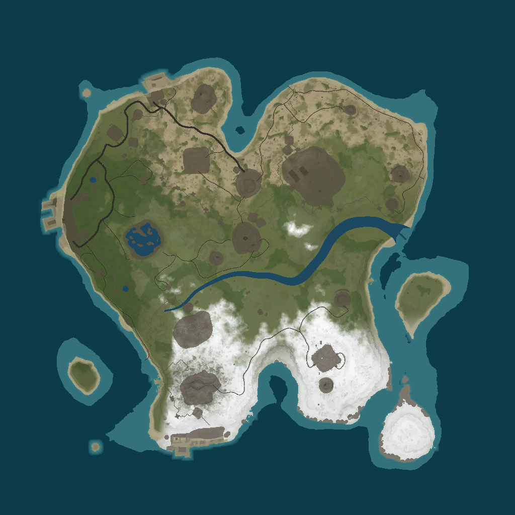
Map image unavailable. Coordinates below remain readable.
Select a point or click the map for coordinates.
Suggested base spots
Algorithm suggestions — check terrain and build restrictions in game.
- · 202 m
- · 323 m
- · 340 m
- · 256 m
- · 344 m
- · 420 m
- · 142 m
- · 288 m
- · 498 m
Monuments & resource sites
| Location | Grid | X | Z | |
|---|---|---|---|---|
| CaveCave | G2 | -265 | 753 | |
| CaveCave | M5 | 670 | 381 | |
| CaveCave | K12 | 315 | -603 | |
| CaveCave | G8 | -197 | -4 | |
| Fishing villageFishing village | I2 | 125 | 834 | |
| HarborHarbor | B6 | -950 | 160 | |
| HarborHarbor | G13 | -287 | -887 | |
| Arctic Research Base AMonument | K11 | 316 | -476 | |
| Sphere TankMonument | H5 | -43 | 332 | |
| Ferry TerminalMonument | E2 | -472 | 813 | |
| lighthouseMonument | D13 | -749 | -889 | |
| lighthouseMonument | C2 | -795 | 756 | |
| Nuclea Missile SiloMonument | H7 | -58 | 88 | |
| PowerplantMonument | J5 | 271 | 394 | |
| Radtown SmallMonument | G11 | -275 | -591 | |
| Stables AMonument | D4 | -663 | 573 | |
| Satellite DishMonument | F10 | -305 | -340 | |
| Underwater Lab BMonument | N15 | 885 | -1127 | |
| Oil rigOil rig | P0 | 1516 | 1185 | |
| Oil rigOil rig | L0 | 477 | 1514 | |
| #2778438472Other | G5 | -284 | 447 | |
| Fishing Villa AOther | N5 | 819 | 350 | |
| Fishing Villag COther | E11 | -560 | -494 | |
| pondOther | C5 | -769 | 360 | |
| pondOther | D8 | -617 | -148 | |
| Tunnel EntranceOther | D10 | -609 | -303 | |
| Tunnel EntranceOther | K12 | 432 | -744 | |
| Tunnel EntranceOther | F6 | -351 | 252 | |
| Tunnel EntranceOther | N4 | 759 | 582 | |
| Tunnel EntranceOther | I9 | 12 | -258 | |
| HQM QuarryHQM Quarry | K3 | 434 | 693 | |
| Stone QuarryStone Quarry | K9 | 388 | -201 | |
| Sulfur QuarrySulfur Quarry | M6 | 629 | 242 | |
| Power Sub BigRoadside | G12 | -281 | -724 | |
| Power Sub BigRoadside | E3 | -559 | 664 | |
| Power Sub BigRoadside | I4 | 146 | 544 | |
| Power Sub BigRoadside | I4 | 139 | 499 | |
| Power Sub BigRoadside | H6 | -26 | 184 | |
| Power Sub BigRoadside | I6 | 11 | 161 | |
| Power Sub BigRoadside | F9 | -326 | -236 | |
| Power Sub BigRoadside | C7 | -814 | 101 | |
| Power Sub BigRoadside | E4 | -581 | 536 | |
| Power Sub BigRoadside | C6 | -814 | 281 | |
| Power Sub SmallRoadside | C7 | -836 | 23 | |
| Power Sub SmallRoadside | C6 | -843 | 260 | |
| Power Sub SmallRoadside | F3 | -441 | 722 | |
| Power Sub SmallRoadside | H5 | -101 | 405 | |
| Safe zoneSafe zone | E7 | -534 | 84 | |
| Water wellWater well | F8 | -418 | -140 | |
| Water wellWater well | D8 | -743 | -76 | |
| Water wellWater well | E5 | -534 | 357 | |
| Farm base spotBase suggestion | L7 | 460 | 131 | |
| PvP base spotBase suggestion | H3 | -75 | 675 | |
| PvP base spotBase suggestion | D7 | -675 | 75 |
No locations match this search.
Map data details
Static resource sites (such as quarries and wells) and landmarks come from parsed map data. Live ore, tree and collectible spawns are not tracked. World origin is map center; +X east, +Z north. Grid positions use nominal 146.3 m cells; custom-map alignment should be checked in game. Off-map coordinates remain in the table but are not placed outside the image.
Map ID 18932 · Procedural Map · checked 11 Nov 2026, 11:51 UTC. Base algorithm 1 · calculated 07 Nov 2026, 03:51 UTC. Algorithm scores are relative heuristic values, not a safety probability.
Similar servers
Rustoria.co - EU East Medium
563 / 600 players · EURustafied.com - EU Medium - Large
243 / 300 players · EuropeEU FunServer x10000000|PVPBATTLEFIELD|KITS|TP|MAZE|KOTH|SF|RAID
186 / 225 players · EuropeRusty Moose |EU Biweekly|
184 / 200 players · EuropeData notes
Server monitoring data · .