Enshrouded Server by emeraldhost.de
- Region
- Europe
- Gather rate
- 1x
- Team size
- 8
Server address 157.90.129.189:30037
This wipe
Estimated wipe cycle Unknown
Last reported wipe: about 2146 hours before last check; wipe type unconfirmed.
Wipe history
Wipe history (1)
| Date | Wipe type | Source |
|---|---|---|
| Type unconfirmed | a2s |
Population
Wipe Replay
Not enough history with recorded wipe boundaries to replay this server.
24h population history
Validated raw samples · UTC · –
Insufficient samples. No population curve is generated.
Point or tap the curve to inspect a recorded sample.
| Average | Peak | Minimum | Validated samples | Coverage |
|---|---|---|---|---|
| Unknown | Unknown | Unknown | 0 | 0% |
49 suspect or unvalidated records were excluded from statistics and the curve. Historical records were checked against their own recorded capacity, never the current capacity.
Queue · 24h
No queue was reported in 49 valid samples. Samples do not measure wait time.
–
No validated activity cells are available.
7-day pop history
7d population history
Peak count per 60-minute bucket · UTC · –
Insufficient samples. No population curve is generated.
Point or tap the curve to inspect a recorded sample.
| Average | Peak | Minimum | Screened buckets | Coverage |
|---|---|---|---|---|
| Unknown | Unknown | Unknown | 0 | 0% |
169 suspect or unvalidated records were excluded from statistics and the curve. Historical records were checked against their own recorded capacity, never the current capacity.
Mean and minimum describe bucket maxima, not raw-sample average population or the true minimum. The API aggregates population and capacity independently; exact within-bucket pairing is unavailable.
30-day pop history
30d population history
Peak count per 120-minute bucket · UTC · –
Insufficient samples. No population curve is generated.
Point or tap the curve to inspect a recorded sample.
| Average | Peak | Minimum | Screened buckets | Coverage |
|---|---|---|---|---|
| Unknown | Unknown | Unknown | 0 | 0% |
234 suspect or unvalidated records were excluded from statistics and the curve. Historical records were checked against their own recorded capacity, never the current capacity.
Mean and minimum describe bucket maxima, not raw-sample average population or the true minimum. The API aggregates population and capacity independently; exact within-bucket pairing is unavailable.
Current map
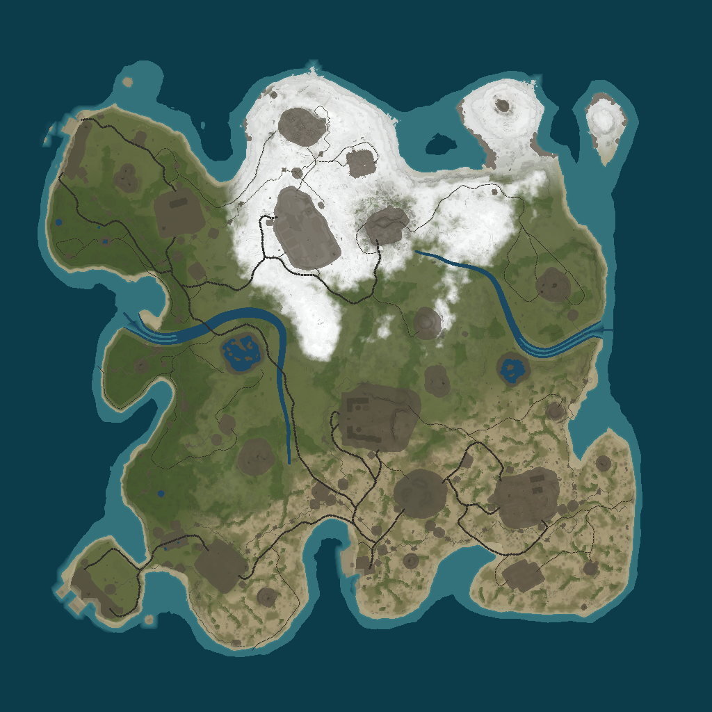
Map image unavailable. Coordinates below remain readable.
Select a point or click the map for coordinates.
Suggested base spots
Algorithm suggestions — check terrain and build restrictions in game.
- · 276 m
- · 354 m
- · 428 m
- · 268 m
- · 269 m
- · 374 m
- · 162 m
- · 190 m
- · 453 m
Monuments & resource sites
| Location | Grid | |
|---|---|---|
| Cave | D5 | |
| Cave | H12 | |
| Cave | M10 | |
| Cave | H16 | |
| Cave | D10 | |
| Cave | L15 | |
| Cave | Q13 | |
| Fishing village | H18 | |
| Harbor | C16 | |
| Harbor | B4 | |
| Airfield (Monument) | I6 | |
| Arctic Research Base A (Monument) | K4 | |
| Sphere Tank (Monument) | L9 | |
| Ferry Terminal (Monument) | J15 | |
| Junkyard (Monument) | L13 | |
| lighthouse (Monument) | D2 | |
| lighthouse (Monument) | E17 | |
| Nuclea Missile Silo (Monument) | P8 | |
| Powerplant (Monument) | O14 | |
| Radtown Small (Monument) | K6 | |
| radtown (Monument) | E15 | |
| Stables B (Monument) | G11 | |
| Stables A (Monument) | F7 | |
| Satellite Dish (Monument) | I3 | |
| Swamp B (Monument) | O10 | |
| Underwater Lab C (Monument) | Q0 | |
| Water Treatment Plant (Monument) | K11 | |
| Oil rig | T19 | |
| Oil rig | M0 | |
| #63296637 (Other) | O16 | |
| Apartment Complex (Other) | F6 | |
| Fishing Villa A (Other) | S14 | |
| Fishing Villag C (Other) | C10 | |
| pond (Other) | E13 | |
| pond (Other) | B6 | |
| Ruin A (Other) | F8 | |
| Ruin C (Other) | E11 | |
| Tunnel Entrance (Other) | H2 | |
| Tunnel Entrance (Other) | N5 | |
| Tunnel Entrance (Other) | D12 | |
| Tunnel Entrance (Other) | Q17 | |
| Tunnel Entrance (Other) | N9 | |
| Tunnel Entrance (Other) | Q10 | |
| ziggurat (Other) | C6 | |
| HQM Quarry | O2 | |
| Stone Quarry | P11 | |
| Sulfur Quarry | Q15 | |
| Gas Station (Roadside) | J13 | |
| Power Sub Big (Roadside) | G18 | |
| Power Sub Big (Roadside) | C4 | |
| Power Sub Big (Roadside) | J13 | |
| Power Sub Big (Roadside) | I4 | |
| Power Sub Big (Roadside) | F6 | |
| Power Sub Big (Roadside) | E7 | |
| Power Sub Big (Roadside) | E9 | |
| Power Sub Big (Roadside) | Q8 | |
| Power Sub Big (Roadside) | Q14 | |
| Power Sub Big (Roadside) | F11 | |
| Power Sub Big (Roadside) | G12 | |
| Power Sub Big (Roadside) | E14 | |
| Power Sub Big (Roadside) | P14 | |
| Power Sub Big (Roadside) | M14 | |
| Power Sub Big (Roadside) | D16 | |
| Power Sub Big (Roadside) | E15 | |
| Power Sub Big (Roadside) | F16 | |
| Power Sub Big (Roadside) | I14 | |
| Power Sub Big (Roadside) | E14 | |
| Power Sub Big (Roadside) | K14 | |
| Power Sub Big (Roadside) | J14 | |
| Power Sub Big (Roadside) | K15 | |
| Power Sub Big (Roadside) | M14 | |
| Power Sub Small (Roadside) | G16 | |
| Power Sub Small (Roadside) | M13 | |
| Power Sub Small (Roadside) | D17 | |
| Power Sub Small (Roadside) | B5 | |
| Power Sub Small (Roadside) | P14 | |
| Power Sub Small (Roadside) | C3 | |
| Power Sub Small (Roadside) | F5 | |
| Power Sub Small (Roadside) | F6 | |
| Power Sub Small (Roadside) | C15 | |
| Power Sub Small (Roadside) | N14 | |
| Power Sub Small (Roadside) | O13 | |
| Power Sub Small (Roadside) | H6 | |
| Power Sub Small (Roadside) | F15 | |
| Power Sub Small (Roadside) | K12 | |
| Power Sub Small (Roadside) | L14 | |
| Power Sub Small (Roadside) | K15 | |
| Supermarket (Roadside) | D3 | |
| warehouse (Roadside) | N12 | |
| Safe zone | G9 | |
| compound (Safe zone) | G15 | |
| Water well | E7 | |
| Water well | E4 | |
| Water well | E10 | |
| Water well | B7 | |
| Farm base spot (Base suggestion) | N7 | |
| PvP base spot (Base suggestion) | F13 | |
| PvP base spot (Base suggestion) | J3 |
No locations match this search.
Map data details
Static resource sites (such as quarries and wells) and landmarks come from parsed map data. Live ore, tree and collectible spawns are not tracked. Grid positions use nominal 146.3 m cells; custom-map alignment should be checked in game. Off-map coordinates remain in the table but are not placed outside the image.
Map ID 23628 · Procedural Map · checked 16 Nov 2026, 16:29 UTC. Base algorithm 1 · calculated 16 Nov 2026, 16:29 UTC. Algorithm scores are relative heuristic values, not a safety probability.
Similar servers
MONDAY | PIXEL RUST | x2 | EU | UA | WIPE 16.11
Also in the same country (DE).
250 / 280 players · Europe[EU] Brits PvE Worlds 2.0 | RUST MMORPG | Quests | Custom Weapo
Also in the same country (DE).
237 / 2000 players · EuropeKRAKEN | X10 | EU | KITS | RP | FPS+
Also in the same country (DE).
213 / 400 players · EuropeRustoria.co - EU East Medium
289 / 325 players · EUServer monitoring data · .